2006 - EUROPE HOLIDAY TURKEY PART 3
My trip to Turkey was an amazing experience few really get to do but it is highly recommended.
My first day exploring Turkey was the day i landed and we proceeded through the countryside and down towards the Gallipoli peninsula. This was a few hours driving overall.
We visited the hotel we were to stay at for next 7 days and then headed off late in afternoon to Anzac Cove which was only 10mins drive or 4-5km away in a straight line...
I was really eager to see this historic battlefield after reading for so long and having had family relatives nearly serve here but they ended up in Egypt in 1916 instead.
The first thing that strikes you as you come over the hills into the national park that Anzac Cove is now preserved as, is just how beautiful the whole area is..... As i have told many people time and time again, if it wasn't for a horrific war, Anzac Cove would of made for a beautiful spot to spend a deployment at.... alas that was never to be.
It is such a pity that war had to marr such a beautiful location as you will see in future photos i will share... the scenery and ocean views are striking. On the days i attended varied it from cloudy, rain to sunshine and pure beauty...... one can only begin to understand by standing on the many hillsides.
Here we see my first glimpses from the museum centre looking towards Anzac Cove in the distance.

It hard to begin to even to understand that this very cove in 1915 was covered in thousands of men, supplies and marked with death.
Nowadays nearly 100years on it is a decaying shoreline marked with a road which was built after WW1. Since this series of photos in 2006 were taken, a retaining wall has been built by the Turkish government to stop the heavy erosion of the cove been washed away into the ocean.
If you look at first photos of Anzac Cove in 1915, you will see the Cove which was once - pure white sand - stretching maybe 10-20m wide at its biggest section and nowadays it is in some places only 2-5 metres wide. It mainly made up of a mix of sand and pebbly rocks.
Here is a photo from April 25 1915 showing how clean the sandy cove was - compare it to mine....
http://upload.wikimedia.org/wikipedia/commons/b/b4/Anzac_Beach_4th_Bn_landing_8am_April_25_1915.jpg
The northern end of the beach cove where the road cuts through can be seen the northern section of the hills which framed the cove in 1915. In 1915 this road cutting was not there obviously..
During 1915 around 50-100 men regularly seen pulling and pushing moved water carts up this steep hillside side to the top. It is a area of many stories and luckily for us many were captured by early war photographers.....here is the photo showing the water cart been moved in 1915 http://www.anzacsite.gov.au/2visiting/images_walk/03_c01812_lge.jpg
http://www.anzacsite.gov.au/2visiting/images_walk/03_a03632_lge.jpg
http://www.grimshaworigin.org/images/England/GallipoliLanding.jpg
http://www.theage.com.au/ffximage/2005/04/09/anzac_cove_wideweb__430x267.jpg
http://www.anzacsite.gov.au/2visiting/images_gallipoli/anzac_ac_P01130001_L.jpg
Post war Gallipoli was left until around 1919 when a Australian military mission revisited to inspect the site for historical purposes and to collect artifacts for their future preservation. A painting and photo convey the contrast of busy 1915 to 1919 quiet and derelict scene.
http://cas.awm.gov.au/screen_img/ART02839
http://cas.awm.gov.au/screen_img/P03631.232
More views of my visit....
To the north lies Sulva Bay... a hellish plain the British Army would find out about in 1915, along with some Australians...
Note the deep excavations cuts into the hillside for the road retaining wall.
The other half of the Australian's position was found here at North beach and in middle is the Anzac Day grandstand for the massive crowds which now flock there each year to honour the war dead of both nations. The small boat in the foreground lends to some scale to the size of the bay.
Standing high above the north Anzac cove positions and above where the hospitals and supplies once stood, is the dominating Sphinx rock formation.
One of the major grave sites at Anzac Cove area.
Looking south along Anzac Cove you will clearly see the pebbly rock formation. In the distance around the southern most point of Anzac Cove, can be seen another point in the distance... from this area Turkish artillery guns fired regularly hitting Anzac Cove during the entire war campaign. They could never be silenced even with British battleships moored offshore nearby.... which were bombarding them.
A most fascinating map which shows the entire allied defensive positions from Anzac to Sulva Bay in 1915... 2-3 km wide at it best and 6-7km long. They held on from April to December 1915. Brave men....
A scenic grave area with a purple coloured tree adding a touch of colour to the horror of what was once a battlefield.
A typical view of the scrub found around the Anzac positions.
 | ||
The grave many Australians associate with Gallipoli - Private Jack Simpson who carried war wounded back to the rear using his donkey. He died early in the war and has ever since been made a national hero.
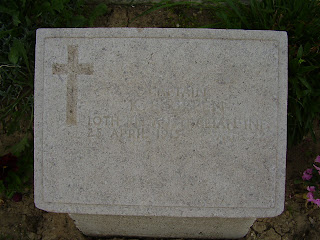
While others dotted around the beach side cemetery have faded and not as well known grave markers.
Part of a old Turkish coastal 1950s defence position lies dormant on the north side of Anzac Cove.
A few photos i took showing me standing on the hollowed grounds of what was once a battlefield.
We leave you with a view of the ocean and the tree standing as a reminder to the horrors of the war in 1915, with the graves of the brave and once were young and not so young Aussie soliders resting quietly. Next story will be further examining the grounds of Gallipoli and the former battlefield itself.


